October 2025
The following topics are discussed on this page:
- surface water availability
- groundwater availability
- water allocation in Alberta
- surface water availability and allocations
- groundwater availability and allocations
Water Availability
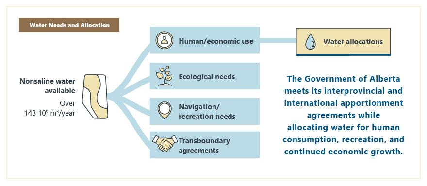
In Alberta, over 143 billion cubic metres (m3) of nonsaline water is available yearly from lakes, rivers, overland flow (runoff), and relatively shallow groundwater. This includes water from lakes and rivers, overland flow (runoff), and relatively shallow groundwater. By understanding how much water is available, and where, the Government of Alberta ensures there is sufficient water to sustain the environment and meet its interprovincial and international apportionment agreements while allocating (licensing) water for human consumption, recreation, and continued economic growth.
Surface Water Availability
Surface water availability is based on the long-term median annual runoff data from Agriculture Agri-Food Canada (AAFC) Annual Unit Runoff in Canada.
The runoff volume reflects the natural state of watersheds and rivers and does not account for flow-regulation structures such as dams.
Local surface water availability only reflects the runoff from within a particular watershed; it excludes runoff as streamflow from upstream watersheds. However, contributions from upstream watersheds are important when determining the total surface water available in a watershed; therefore, the cumulative surface water availability data includes contributions from upstream watersheds.
Groundwater Availability
Groundwater availability is based on the average volume of water from rainfall and snowmelt that enters (recharges) the groundwater system in the sediments above bedrock and the bedrock within 150 m of the surface. After moving through the groundwater system, much of this water eventually replenishes surface water bodies.
Groundwater availability in the deeper part of the groundwater system has not yet been assessed. This deeper groundwater is generally well over 1000 years old and not recharged by recent precipitation.
Groundwater availability is assumed to be equivalent to regional groundwater recharge. The following open file reports (OFRs) describe how regional groundwater recharge was determined in four areas of the province. The approach varied with the different areas due to data availability and hydrogeological characteristics. Groundwater availability in this report is equivalent to
- the safe yield defined in OFR 2017-07: First-Order Groundwater Availability Assessment for Central Alberta,
- the mean of the high and low values for maximum sustained yield defined in OFR 2018-09: First-Order Groundwater Availability Assessment for Southern Alberta, and
- the maximum sustained yield defined in OFR 2019-10: First-Order Groundwater Availability Assessment for the Upper Peace Region, OFR 2020-05: First-Order Groundwater Availability Assessment for the Lower Athabasca Region, and DIG 2021-0024: Groundwater yield continuum for the Cold Lake-Beaver River Basin, Version 2 (GIS data, polygon features).
Where overlap occurred between the central and southern Alberta study areas, the OFR 2018-09 results were used.
Water Allocation in Alberta
Water allocations are the maximum nonsaline water volumes a licence holder may divert under an active Water Act licence. Allocations include water volumes from term and temporary diversion licences. In Alberta, water licences are issued for many types of water use, including agricultural, domestic, commercial, and industrial, which includes the energy sector. Generally, the AER administers the Water Act for the energy industry, while all other uses in Alberta are administered by Alberta Environment and Protected Areas (AEPA). The use of the allocation depends on the type of development in a geographic area. For example, agricultural water use is mainly in southern and central Alberta, while water for oil sands development is mainly in the northeast.
When energy companies apply to use nonsaline water through a term licence, they must state the maximum annual volume of water needed to sustain their project throughout its life cycle. Companies determine the maximum annual volume required based on the year with the highest water demand during the project’s life cycle, including a contingency buffer. Consequently, the actual water use will be less than the allocated maximum annual volume during years of low water demand.
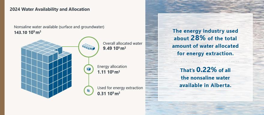
Of the total amount of nonsaline water available, almost 7% (9.49 billion m3) was allocated for use in 2024 (see the following figure). Of all nonsaline water allocated in 2024, about 12% (1.11 billion m3) was allocated to develop energy resources. The remaining 88% of the allocated water in the province was for other uses, such as agriculture, forestry, and municipal.
In 2024, the energy industry used 28% (310 million m3) of its water allocation, which was 0.22% of the nonsaline water available in Alberta. The energy industry allocation represents less than 1% of the calculated nonsaline water available in Alberta.
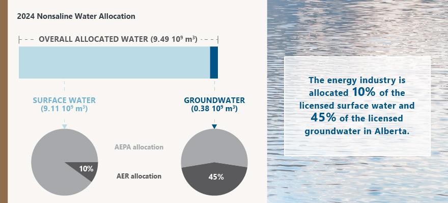
The primary source of nonsaline water allocated in Alberta is surface water, accounting for over 96% of all water allocations. The remaining 4% comes from groundwater. The energy industry is allocated 10% of the licensed surface water and 45% of the licensed groundwater in Alberta (see the following figure).
Oil sands mining accounts for 64% of the energy industry’s total water allocation. Oil sands mining requires a large nonsaline water allocation because it involves water-intensive activities such as mine pit dewatering, solids and bitumen separation, hydraulic transportation of waste solids, and bitumen upgrading.
The allocations for the other extraction technologies are 14% hydraulic fracturing, 9% enhanced oil recovery, and 5% in situ operations. The remaining 8% of the water allocation is for other energy development purposes, such as coal mining/processing, pipeline integrity testing, and hydrocarbon processing.
Surface Water Availability and Allocations
Surface water allocations represent the maximum volume of surface water licensed for diversion from surface runoff, rivers, lakes, and wetlands. Comparing surface water allocation to availability helps identify potential water-short (constrained) areas. Allocations are compared with availability for local or cumulative watershed volumes.
The following map shows the proportion of surface water allocated to the energy industry in Alberta as a percentage of the availability. The data are shown at a watershed scale known as a hydrologic unit code (HUC), which divides an area into progressively smaller watershed units.
The data in this report are shown at the HUC 8 level.
Groundwater Availability and Allocations
Groundwater allocations represent the maximum volume of groundwater licensed for diversion. Groundwater allocations are split into two groups; shallow and deep. Availability is only determined for the shallow part of the groundwater system.
- The first group is allocations from water wells in sediments above bedrock and wells in the bedrock within 150 m of the ground surface (shallow groundwater). These allocations are compared with availability.
- The second group is allocations from water wells in bedrock at depths of more than 150 m (deep groundwater). These allocations are not compared with groundwater availability because deep groundwater availability values are unavailable.
The following maps show groundwater availability in Alberta and allocations to the energy industry by the AER. Comparing groundwater allocation to availability helps identify areas where a high proportion of the available groundwater is allocated and can be investigated further. For example, in northeast Alberta, the watersheds containing most of the oil sands mines show more groundwater allocation than availability. A closer review reveals this is because the groundwater level (or water table) must be lowered to dig and maintain the open-pit mines. To support mine dewatering, the allocated (licensed) volume of water for removal must exceed the amount entering the groundwater system.
While data on groundwater allocation is available across the entire province, availability information has not yet been determined for less developed areas in Alberta. In watersheds where groundwater availability has not yet been determined, the availability will show as ”not yet mapped.” Updates to groundwater availability will be included as they become available from the Alberta Geological Survey.